@eriner @besserwisser I don't know exactly how the census bureau defines rural and urban in this context. Does a city of only 10,000 count as urban for them? That's not represented as orange in the other map obviously
@eriner Yeah, it's gonna be something like that. Obviously there are some big cities in the orange area, but there are definitely a lot missing. You're telling me the only cities in all of California are on that strip to the south east? I'm guessing there's stuff further north, those cities are just a lot poorer. Definitely some more notable urban areas are left out, just don't know exactly which without looking it up.
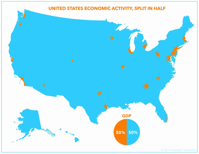
@eriner @besserwisser if I have correctly identified all the areas on my original map, it's these:
New York–Newark–Jersey City – 20,140,470 Los Angeles–Long Beach–Anaheim – 13,200,998 Chicago–Naperville–Elgin – 9,618,502 San Francisco–Oakland–Berkeley – 4,749,008 Washington–Arlington–Alexandria – approx. 6.3 million Dallas–Fort Worth–Arlington – 7,637,387 Houston–The Woodlands–Sugar Land – approx. 7.1 million Boston–Cambridge–Newton – approx. 4.9 million Seattle–Tacoma–Bellevue – approx. 4.0 million Philadelphia–Camden–Wilmington – approx. 6.1 million Miami–Fort Lauderdale – approx. 6.1 million Phoenix–Mesa–Scottsdale – 4,845,832 Minneapolis–Saint Paul – 3,690,261 Detroit–Warren–Dearborn – approx. 4.3 million San Diego–Chula Vista–Carlsbad – approx. 3.3 million Denver–Aurora–Lakewood – approx. 2.9 million Baltimore–Columbia–Towson – approx. 2.8 million Charlotte–Concord–Gastonia – approx. 2.6 million Portland–Vancouver–Hillsboro (OR–WA) – approx. 2.5 million St. Louis – approx. 2.8 million Riverside–San Bernardino–Ontario – approx. 4.7 million San Antonio–New Braunfels – approx. 2.6 million Tampa–St. Petersburg–Clearwater – approx. 3.1 million
which only adds up to 120 million, which is only 35% of the US population

Matt Hamilton
in reply to feld • • •CapitalB
in reply to Matt Hamilton • • •Blue = food
feld
in reply to CapitalB • • •ベッサーヴィッサー
in reply to Matt Hamilton • • •feld
in reply to ベッサーヴィッサー • • •Matt Hamilton
in reply to feld • • •feld
in reply to Matt Hamilton • • •ベッサーヴィッサー
in reply to feld • • •feld
in reply to ベッサーヴィッサー • • •Matt Hamilton
in reply to ベッサーヴィッサー • • •@besserwisser Once again...
#CorporateHeadquartersAreInCities
feld
in reply to Matt Hamilton • • •@eriner @besserwisser if I have correctly identified all the areas on my original map, it's these:
New York–Newark–Jersey City – 20,140,470
Los Angeles–Long Beach–Anaheim – 13,200,998
Chicago–Naperville–Elgin – 9,618,502
San Francisco–Oakland–Berkeley – 4,749,008
Washington–Arlington–Alexandria – approx. 6.3 million
Dallas–Fort Worth–Arlington – 7,637,387
Houston–The Woodlands–Sugar Land – approx. 7.1 million
Boston–Cambridge–Newton – approx. 4.9 million
Seattle–Tacoma–Bellevue – approx. 4.0 million
Philadelphia–Camden–Wilmington – approx. 6.1 million
Miami–Fort Lauderdale – approx. 6.1 million
Phoenix–Mesa–Scottsdale – 4,845,832
Minneapolis–Saint Paul – 3,690,261
Detroit–Warren–Dearborn – approx. 4.3 million
San Diego–Chula Vista–Carlsbad – approx. 3.3 million
Denver–Aurora–Lakewood – approx. 2.9 million
Baltimore–Columbia–Towson – approx. 2.8 million
Charlotte–Concord–Gastonia – approx. 2.6 million
Portland–Vancouver–Hillsboro (OR–WA) – approx. 2.5 million
St. Louis – approx. 2.8 million
Riverside–San Bernardino–Ontario – approx. 4.7 million
San Antonio–New Braunfels – approx. 2.6 million
Tampa–St. Petersburg–Clearwater – approx. 3.1 million
which only adds up to 120 million, which is only 35% of the US population