Search
Items tagged with: urbanism


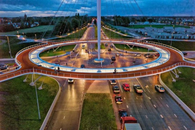
Too bad it's on Instagram rather than an open website, but WOW.
(Following the breadcrumb trail from BikingInLA.com got me there.)
Imginn.com/p/DPUPjhADGUy/
#Fashion #BikeTooter #Urbanism

A new “continuous sidewalk” in #Kitchener. The design differs from regular sidewalks in that it doesn’t dip down to road level at intersections. It continues at an uninterrupted height. This slows cars turning onto the street + reinforces pedestrian priority through the intersections. Same at the driveways, so you don’t get the up-down “roller coaster effect” when you’re #walking, #cycling or using a wheelchair.
#safestreets #urbanism #accessibility


My friend Jiggy Fetil just posted this on facebook.
It was so good I thought I should share. (Original from 'Movement': blackwells.co.uk/bookshop/prod…) #transport #cycling #traffic #urbanism
. 2. Reduce car lanes, add bus and cycle lanes.")
Movement
Our dependence on cars is damaging our health - and the planet's. Movement asks radical questions about how we approach the biggest urban problem, reflecting onblackwells.co.uk

What does it take to move 1000 people?
Smarter mobility infrastructure.
Graphic via @SeattleSubway based on a Sydney graphic from years ago.
#cities #urbanism #PublicTransit #cars #buses

Cycling is now the single largest mode of travel during peak times in the City of London, according to a new report.
Cyclists represent 40% of traffic during peak hours and 27% of traffic throughout the day.
Since 1999, the number of motorists has dropped 64% and the number of cyclists has increased 386%.
#Urbanism #UrbanDesign #ClimateChange #Cycling #BikeTooter #UK #London #Mobility #Transportation
forbes.com/sites/carltonreid/2…

Cyclists Now Outnumber Motorists In City Of London
At peak times, people cycling represent 40% of road traffic in the City and 27% throughout the day.Carlton Reid (Forbes)
7 years ago, while trying to get approval to operate in cities all over the world, #Uber insisted that it would actually reduce traffic. Instead, Uber drivers cruise without passengers 40% of the time. Uber & Lyft no longer claim they reduce traffic, & now admit they actually increase congestion.
So much for “making cities better.”
wsj.com/articles/the-ride-hail…
#Cities #transportation #urbanism #cars #ridehailing #ridesharing #traffic

The Ride-Hail Utopia That Got Stuck in Traffic
Uber and Lyft said they would ease congestion. Instead they made it worse.Eliot Brown (The Wall Street Journal)
This actually isn’t surprising at all, but it still needs to said over & over — the biggest barrier to more urban biking in cities is the fear of cars.
“A study confirms that if we are serious about getting people on bikes, they need a safe place to ride.”
Via @lloydalter #TreeHugger #bikes #cities #urbanism #cars #BikeLanes
treehugger.com/fear-of-cars-bi…

Biggest Barrier to Biking Is the Fear of Cars
If we are serious about getting people on bikes, they need a safe place to ride.Lloyd Alter (Treehugger)
When we see streets primarily as space to move cars, we miss out on the wonderful places for people that streets can be. And our cities are less successful for it. Actually, it’s not even good for moving cars! Rotenturmstraße’s before-&-after transformation in #Vienna via former Deputy Mayor Birgit Hebein.
#StreetsForPeople #cities #urbanism #streets #transportation #cars #Austria #cars #people


Remember this? A simple, creative way to make the really important point about the need for child-safe, all-ages & abilities PROTECTED bike-paths. Paint isn’t safe infrastructure, any more than stuffed animals are — if you wouldn’t let your kids ride in it, it isn’t safe, Period. #Berlin via @umwerfer.
#LetKidsBike #Urbanism #BikeLanes #Cities #transportation #bikes #cars #city #kids #car

I wrote a technical guide showing how you can create your own orthorectified (aka satellite view/bird mode) imagery, point clouds and 3D models of streets with nothing but a 360 degree camera mounted on bicycle helmet, and the open source photogrammetry software OpenDroneMap.
Why might you want to do this? With your own up-to-date, highly detailed point clouds and imagery you could:
- quantify and communicate inefficient road space allocation
- record necessary infrastructure repairs
- take measurements such as lane and cycleway widths
- measure footpath obstructions in 3D and rate pedestrian amenity
- map kerb features on OpenStreetMap
- survey street parking using the new OSM spec: wiki.openstreetmap.org/wiki/St…
- 3D print a model of your home street!
jakecoppinger.com/2022/12/crea…
#openstreetmap #opendronemap #maps #photogrammetry #curb #kerb #parking #cycling #urbanism #mapping

Creating aerial imagery with a bike helmet camera (GoPro) and OpenDroneMap - Jake Coppinger
This technical guide details how you can create your own orthorectified (aka satellite view/bird mode) imagery, point clouds and 3D models of streets with nothing but a 360 degree camera mounted on bicycle helmet, and the open source photogrammetry s…https://jakecoppinger.com/author/jakcop_t1chd5/#author (Jake Coppinger)
#placemaking #PublicSpace #skating #cities #Urbanisme #Urbanism

Tonight I am bringing some #transport, #bikes, #cycling, #urbanism and #antiCar #memes.
I hope you enjoy them and are radicalised like I am. Once you start seeing how we've been trapped by #carDependency you cannot unsee it again.
Let's fight for space for people, cities that are walkable, accesible, clean, green and safe.
Of course, please contribute your own memes to the thread and also radicalise your family, workmates and friends!
 glaring at a happy looking tortoise passing them all while riding on its red pushbike.")