Search
Items tagged with: openstreetmap

📝 An #OpenStreetMap contributor wrote an entry: landuse=forestry.
Read more here: https://www.openstreetmap.org/user/Zkir/diary/403231
Zkir's Diary | landuse=forestry | OpenStreetMap
OpenStreetMap is a map of the world, created by people like you and free to use under an open license.OpenStreetMap
#EveryDoor verfügbar auf @fdroidorg : https://f-droid.org/de/packages/info.zverev.ilya.every_door
"This editor does not make you think. Just go to a mall, and start Every Door. You'll see mapped #shops around you: tap on the checkmark for any that are still there, and add shops that are not on the map. That's the entire process: you can keep your entire town up-to-date thanks to this simple editor."

Every Door | F-Droid - Free and Open Source Android App Repository
Mobile OpenStreetMap editor for POI & micromappingf-droid.org


Ooh! I will pass by! I'll also do an 'Introduction to #OpenStreetMap' tomorrow, in the Hardware Hacking Area.
Also, I forgot to bring my heap of stickers, but I see that you have plenty to hand out. I might temporarily move a stash to my intro session.


(1) Open https://www.openstreetmap.org/profile/edit
(2) Add <a href="https://en.osm.town/@YOUR_NAME" rel="me">Mastadon</a>
(3) Open https://en.osm.town/settings/profile
(4) Remove Link and(!) Label of your existing OSM Profile link (if present), then save
(5) Re-add Label and Link
(6) Visit your Mastdon profile, the OSM link is now green.

OSM Town | Mapstodon for OpenStreetMap
An independent, community of OpenStreetMap people on the Fediverse/Mastodon. Funding graciously provided by the OpenStreetMap Foundation.Mastodon hosted on en.osm.town
This Christmas, I've finally bitten the bullet and done some serious contributing to @openstreetmap (and also joined the OSM Foundation while I was at it). Honestly, I think it's one of the great wonders of the #OpenSource internet, so I wrote a blog post about why I'm contributing (and you should too)
https://andreasthinks.me/posts/OSM_for_christmas/osm_for_xmas.html
#GIS #openstreetmap #GeoSpatial #christmas #DataScience #data

Andreas Varotsis - Why I’m Contributing to OpenStreetMap for Christmas…
…and maybe you should too!andreasthinks.me
#Google has a revenue of $162bln and 1.8bln regular users. If we divide these numbers, the value of the services people use giving away their #privacy is $7.5/mo.
But you can have all these services for free (or very small monthly fees) in a privacy-respecting environment: #encrypted email from @protonmail or @Tutanota, online office suite from @cryptpad or @ViOffice, cloud storage Proton or ViOffice, #openstreetmap for maps, #duckduckgo, or @StartpageSearch for search. As simple as that! 😀

#Reparieren statt wegwerfen! Dafür gibt es (ehrenamtliche) Reparatur-Cafés. Für München findet Ihr diese beispielsweise auf den Seiten des AWM (Abfall-Wirtschaftsbetrieb München). Für die Standort-Anzeige wird nicht etwa auf GMaps, sondern auf #OpenStreetMap gesetzt 🤩
https://www.awm-muenchen.de/vermeiden/reparieren-statt-wegwerfen/repair-cafes
Is there anyone out there
coding with #BevyEngine and
likes #OpenStreetMap? In 3D and VR?
To help my project to get started?
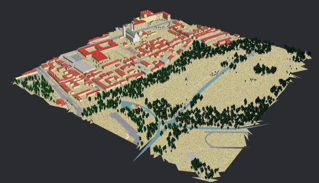
A zoom 15 glb-tile of OSM by OSM2World rendered with Bevy:
I genuinely feel like #Protomaps is not nearly getting the attention it deserves
We can drop a single file on a static host and get stylable vector maps? Magic ✨
In combination with Maplibre it's a game changer for 99% of web map use cases 👏
#OpenStreetMap #MapLibre #Maps #Mapstodon
A free and open source map of the world
Protomaps is an alternative to Map APIs that you run on your own cloud storage.protomaps.com
https://streets.gl/#49.13445,16.73294,10.50,1.00,556.31
#osm

Streets GL
Streets GL is a OpenStreetMap 3D renderer that allows to explore the whole world in great detailstreets.gl

Tvořte mapy v projektu Missing Maps
Týmy Lékařů bez hranic často působí v oblastech, pro které neexistují dostatečně podrobné mapy. Zapojte se do projektu Missing Maps a vytvářejte mapy podle satelitních snímků, aniž byste opustili svůj pokoj.lekari-bez-hranic.cz
Maning, (one of our OSM pioneers) promptly responded by creating a database they can use, and a few months later, they got another email, sharing additional data to add to OSM.
https://openstreetmap.org/changeset/4078299#map=0/18/122

Changeset: 4078299 | OpenStreetMap
OpenStreetMap is a map of the world, created by people like you and free to use under an open license.OpenStreetMap

https://community.openstreetmap.org/t/overturemaps-org-big-businesses-osmf-alternative/6760
#OpenSource #OpenStreetMap

Overturemaps.org - big-businesses OSMF alternative
See https://overturemaps.org/OpenStreetMap Community
Why might you want to do this? With your own up-to-date, highly detailed point clouds and imagery you could:
- quantify and communicate inefficient road space allocation
- record necessary infrastructure repairs
- take measurements such as lane and cycleway widths
- measure footpath obstructions in 3D and rate pedestrian amenity
- map kerb features on OpenStreetMap
- survey street parking using the new OSM spec: https://wiki.openstreetmap.org/wiki/Street_parking
- 3D print a model of your home street!
https://jakecoppinger.com/2022/12/creating-aerial-imagery-with-a-bike-helmet-camera-and-opendronemap/
#openstreetmap #opendronemap #maps #photogrammetry #curb #kerb #parking #cycling #urbanism #mapping

Creating aerial imagery with a bike helmet camera (GoPro) and OpenDroneMap - Jake Coppinger
This technical guide details how you can create your own orthorectified (aka satellite view/bird mode) imagery, point clouds and 3D models of streets with nothing but a 360 degree camera mounted on bicycle helmet, and the open source photogrammetry s…https://jakecoppinger.com/author/jakcop_t1chd5/#author (Jake Coppinger)
E-Mail Clients: #fairmail #thunderbird
Chat: #signal
Office: #libreoffice
Browser: #firefox #fennec
Phone: #VollaPhone #googlefrei
Password: #keepass
Social: #mastodon
Video: #newpipe
Map: #openstreetmap
VPN: #openvpn
Radio: #radiodroid
News: #hamburger
Route: #osmand
Tracking und Werbeblocker: #pihole auf #rasberrypi
E-Mail Verschlüsselung: #pgp
Cloud Speicher in Deutschland: #MyStorBox
Captcha Plugin for Joomla! 3 and 4. : #aimy
https://www.nobohan.be/2022/09/06/openardennemap-ete-2022/
#cartographie #belgique #ardennes #OSM

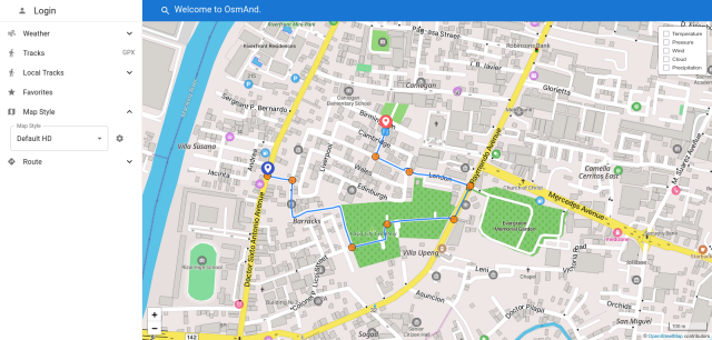
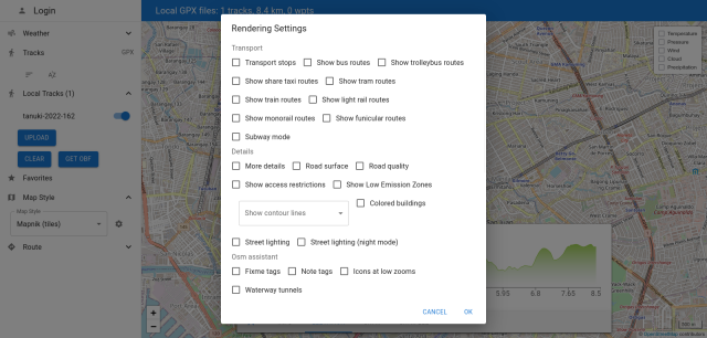
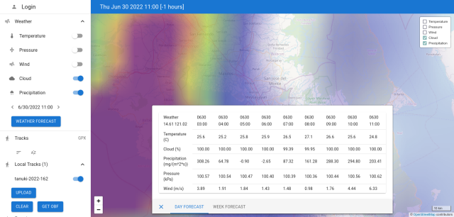
Check out https://osmand.net/map, and plan your trips with routing, and various map rendering options, while doing so in the comfort of your desktop browser.
It even includes weather forecasts, if you're trying to avoid getting wet for your weekend ride.
You don't even need to register for an #OsmAnd, or #OpenStreetMap account to use it.