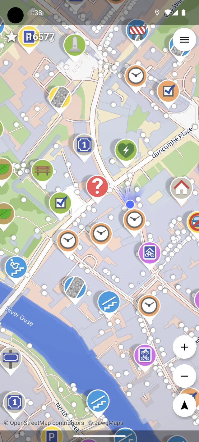
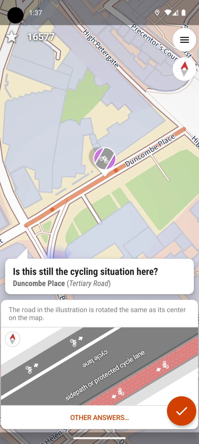
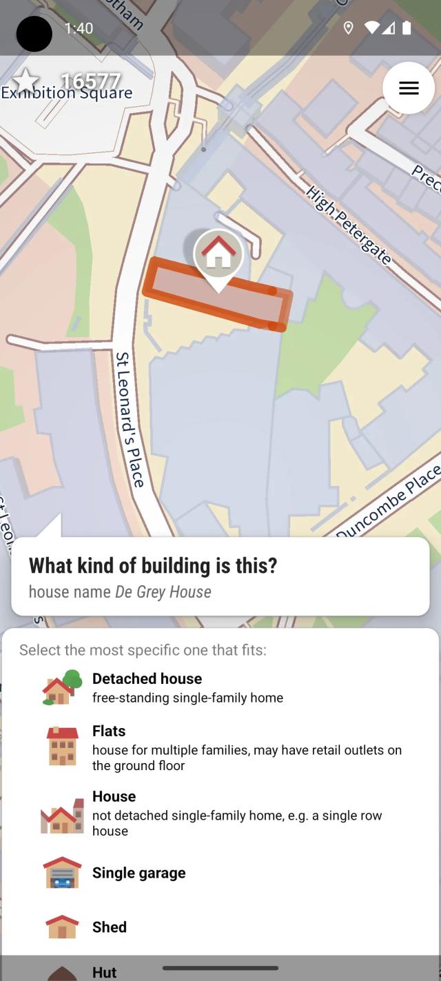
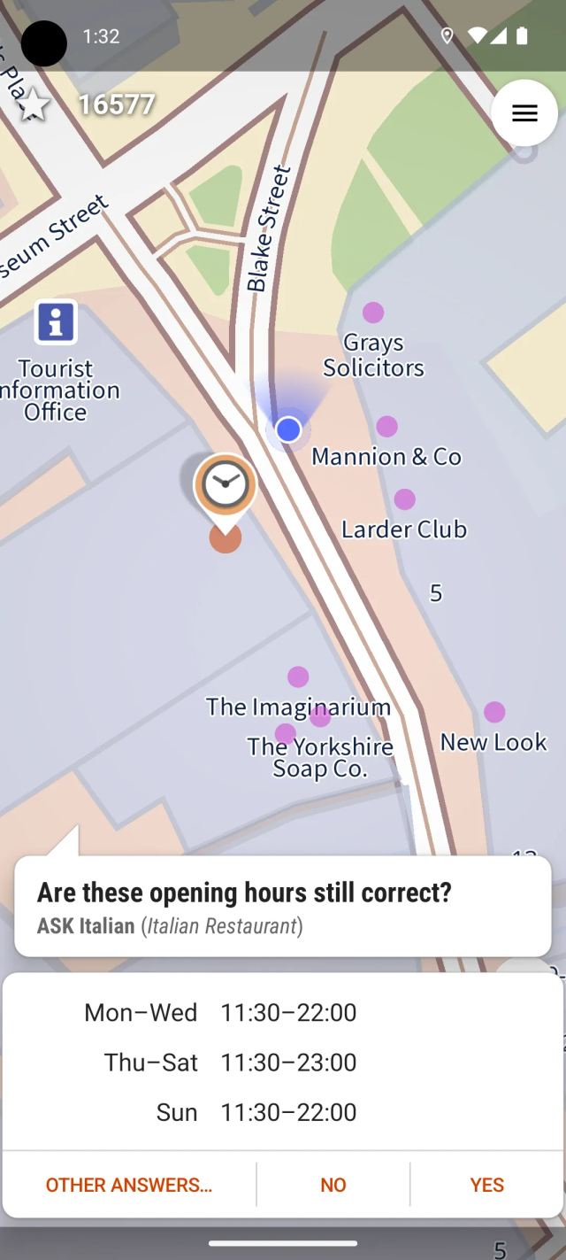
Items tagged with: OpenStreetMap

Search

Items tagged with: OpenStreetMap


I saw @richlv post the other day about #GoogleMaps vs #OpenStreetMap and needed to share this as well.

I first noticed this difference a few months back when my driving instructor couldn't find the location that I sent him (because Google Maps doesn't show it at all). Only after I added "Fairway Walk" (see Google Screenshot for the name/location) as a named road to OSM, did it get added to Google Maps. There are still apartments missing from the Google Maps though.


Sensitive content


Sensitive content


Had a blast at our little #OpenStreetMap birthday celebration. 🍰 🧉

It ended up being too windy to fly drones for long. Instead we recorded street-level images for #panoramax and GPS tracks, in addition to doing a lot of live surveying – using a huge range of tools that allow contributing to OSM!

In no particular order we at least used: @everydoor, @streetcomplete, @MapComplete, @CoMaps, HOTOSM's ChatMap, iD and JOSM.

Having so many different ways of making contributions is a real feature.


Happy 21st Birthday @openstreetmap! 🍰 🥳 🎈

Gonna meet up with friends to celebrate, do some on-the-ground surveying, probably also walk around with a 360° cam to get imagery for @panoramax. And fly a drone, to get some nice aerial imagery while we're at it! 🗺️ 📷

And of course have some cake too 😂

#OpenStreetMap #panoramax


Even on the night before the party, we were agonizing over the perpetual question - what editor to teach to newcomers?

And after the workshop and the latest mapping party, I think I have a new and improved idea.

  1. We always introduce #CoMaps (and earlier Organic Maps) to newcomers, focusing on it as a means of using OSM. But we avoid using its editor - offline data can be confusing and (in the presence of concurrent editors) can more easily lead to duplication.

But if we want people to recommend CoMaps to other, less technical people…they may want the latter to be able to add places without installing another app.

  1. I have long admired StreetComplete’s gamified interface, but always figured that it would cause issues in a mapping party.

But perhaps we can incorporate it after all? The people it is most likely to cause issues for are the #Vespucci users, and they are experienced enough (and Vespucci’s tooling is good enough) to handle upload conflicts.

Another issue is that if a user adds some data using a #StreetComplete layer, it takes time for quests to appear for it.

  1. #MapComplete is good because it puts together the things people coming from Google Maps often expect from OSM - map data, photos, and ratings+reviews. The questions and the photo-taking may also add some variety and fun, and the photos also help other mappers verify the data and add details.

So here’s the new idea -

  1. We practice adding 1-3 POIs with CoMaps. There may be duplication, but that’s okay, we (the organizers) will clean it up later as we usually do.
  2. Then, we add 5-10 POIs with MapComplete.
  3. Finally, we try out StreetComplete to add more details to the streets and POIs. We will use SC’s team mode to divide quests between people on the same team.

I’ll test the viability of this process soon.

(Vespucci will go back to being an editor for regular participants.)

#OpenStreetMap #OSM #contraMaps


Some postmortem notes about our 19th mapping party…

en.osm.town/@OSMIndia/11493311…

On a positive note, I think this was a productive party. 8 out of 10 participants were experienced mappers, and I’m happy with the data we added to the market. 👍

On the other hand, there were hardly any people from Noida - clearly, the publicity needs more work 😐

One participant recommended posting on Luma, so I guess we’ll be trying that.

Also, if you like my work, please support me on Liberapay. I’m unemployed, and rely on the community’s support for my contributions.

#OpenStreetMap #OSM #contraMaps


Mal ab davon, dass ich bisher noch nie eine funktionierende #mapcomplete Karte erstellen konnte 🙈 ...

... träume ich noch von der Tourismus Karte. Die, bei der man einfach während dem Sightseeing allerlei Dinge mappen kann ohne die Karte wechseln zu müssen.

Dinge hinzufügen, Daten erweitern, Bilder und Bewertungen hinzufügen ist das Ziel.

1/2

#osm #openstreetmap


Mal eine Frage: Was bevorzugt Ihr (und ggf. warum -> Kommentare)?
#streetcomplete #MapComplete #osm #openstreetmap

  • streetcomplete (70%, 21 votes)
  • mapcomplete (3%, 1 vote)
  • situationsbedingt (6%, 2 votes)
  • hä?!? (20%, 6 votes)
30 voters. Poll end: 3 weeks ago


is there an "easy" web based (usable with full sized computer) editor for #OSM ?

I'm looking for one I can use to correct/add things like info about local businesses (such as opening hours, whether a business exists at that location)

I do have an OSM account and have looked on the main site but I click on an element and get all sorts of stuff and am worried about putting in the wrong tag or knackering something on the map that someone else has made..

#OpenStreetMap


As you might know, we have an #Android app version of #MapComplete in the works, which makes it even easier to see and edit #OpenStreetMap

After a bit of initial testing, we are opening up the test program to our followers here on Mastodon.

If you want to join the beta testers, send an email to info@mapcomplete.org

Any issues? Head over to mapcomplete.org/issues


"These features rely on tons of our user-generated data—the fuel of the platform... Crucially to the business, we users perform this crucial labor for free and without any say in the direction of the platform."

And this is why I stopped contributing to #MapyCom (and pretty much all proprietary platforms) and started contributing to #OpenStreetMap and #WikimediaCommons last year.

bikepacking.com/plog/when-we-g…

#Komoot #komooted


I added my first doorbell camera on #OpenStreetMap today with @MapComplete, and I would advise others to do the same in their area!

Doorbell cameras are a growing surveillance measure many are still unaware of. On OSM, there's a tag to mark a camera as being a doorbell camera: camera:type=doorbell. They're especially easy to add via MapComplete.

#OSMTaggingTips


TIL there’s a “native” #MapComplete in F-Droid! And it utterly blows away the web version and the “installed” PWA in terms of responsiveness… (I tested these with Fennec)

What magic is this, @MapComplete ? 😳

#contraMaps #OpenStreetMap #OSM


Great! Welcome to the #OpenStreetMap community 🙂

Please note that the #OrganicMaps developer community has forked it under the name @CoMaps due to governance and future takeover concerns. #CoMaps has replaced Organic Maps as my first recommendation for an OSM app.

#OsmAnd has been mentioned as a more powerful alternative to CoMaps/Organic Maps. However, if someone doesn’t need offline maps (maybe they’re low on storage), or maybe you need to share a place on OSM with someone who doesn’t have CoMaps/Organic Maps/OsmAnd installed - check out osmapp.org/ (@osmapp), which is a progressive web app with multilingual vector tiles, navigation, photos from Wikimedia Commons, 3D buildings, indoor maps, and more.

mapcomplete.org/ (@MapComplete) is another web app worth checking out. It works on all devices, the concept of themed maps helps you discover some of the possibilities of OSM, and it has a beginner-friendly quiz-like editor similar to StreetComplete.

Most notably, #MapComplete shows you photos of places (including photos of restaurant menus!) from #Panoramax (@panoramax) , and ratings and reviews from #MangroveReviews (@mangroveReviews) …and it allows you to easily add them yourself using only your OSM account. Panoramax and Mangrove Reviews are libre (“open”) data projects just like OSM, and can help all OSM apps.

I’ve heard that Magic Earth (proprietary) uses OSM data and has traffic information too. Worth a look?


Mapcomplete.org ist getting better and better.

A few days ago I discovered that its possible to add manmade bird nests. I was standing near a stork's nest when I found the topic. And directly added a picture.

I also found by chance that beehives can be added. And that there are also viewpoints to add under the theme of nature.

It would be nice if there was some information and not find by chance.

something new thats still hidden under some Theme?

#MapComplete #openstreetmap #osm


One thing I miss in #OpenStreetMap, #Organicmaps and so on are contextual images. One thing I don't miss are all the ads. Wikimedia has a lot of contextual photos released under a #CreativeCommons license. (wikishootme.toolforge.org/) Couldn't it be possible to create an integration for OSM to pull images from Wikimedia into a map-app like Organic Maps? That would be awesome.


#OpenStreetMap for #Portland is so extremely outdated that I discovered there used to be a restaurant called Daruma Sushi that closed in 2019 in the same space that is currently hosting Feral. Orange & Blossom was missing entirely. I tried to update both, but since #OrganicMaps didn’t let me log in, I’m not sure if my updates will sit in a queue somewhere…

In any case, #OSM is far from being a reliable #GoogleMaps replacement, unless you somehow already know exactly where you’re going 🙃


I contributed to #OpenStreetMap! But I didn't know that Cyclofix was going to ask me questions, so now I have to go back and test the pump and such, even though my bike is perfectly fine 😂 mapcomplete.org/cyclofix


I am uploading pictures (#PanoramaX), as well of other details, in the bicycle parking theme of #MapComplete. I like to take the pictures and upload several afterwards.As sometimes I didn't remember whether a bicycle parking has already pictures or not I find useful this simple overpass(overpass-turbo.eu/)that shows you which ones in an area lack them.

I share it JIC anybody find it useful:

[out:json];
node["amenity"="bicycle_parking"][!"panoramax"]({{bbox}});
out;
#OpenStreetMap


A big thanks to all 11 participants of the 18th #OpenStreetMap #Delhi Mapping Party! 🙂

We hope you will join us again to help make #OSM better. Each mapper counts!

#OsmNcr #India


The #OpenStreetMap community of #Delhi invites everyone to our 18th mapping party - our first one in Vaishali!

🗓️ Date - Sunday, 13th of July
🕙 Time - 4 PM to 7 PM
📌 Location - Vaishali Metro Station
osmcal.org/event/3819/

Visit the link to learn more, register, and add the event to your calendar.

The more the people, the greater our impact. Each mapper matters!

#OsmNcr #OSM
#BoostsAppreciated
#Ghaziabad #India


A new version is released: v0.54.0

Some new features are:

- Some types of objects have gotten a *copy* button. If a similar object is nearby, you can add it easily to #OpenStreetMap with a few taps
- Reviews (powered by @mangroveReviews are now parsed with markdown (spoilers: the develop version has some more improvements wrt reviews)
- There is now a user preference that forces mapcomplete to remember the layer state


Been adding restaurant ratings and reviews to Mangrove Reviews @mangroveReviews using MapComplete @MapComplete

I’ve written 6 so far, and there’s more to come! Plenty of WIP drafts to finish 🙂

This really plays to my strengths, combining my love for

  • writing,
  • improving OpenStreetMap, free data, and freedom-respecting software,
  • reviewing (as a child, I liked to review the theatre I watched with my parents…my parents and their theatre friends would often ask me for my review after the show, and would listen to me intently 🥺)
  • …and trying new things to eat and drink!

If you like my open data reviews and photos, please support me on Liberapay! I need to be able to afford eating out to continue reviewing 😅

PS MapComplete currently removes all line breaks from the reviews it displays (which breaks things like paragraphs and bullet lists), and Mangrove Reviews truncates the text of the reviews it displays. So there’s no perfect way to view the reviews right now…I’ve let the developers know about these issues and they will hopefully fix them soon.

#MangroveReviews #MapComplete #OpenStreetMap #OSM #FreeSoftware #Libre #FreedomRespecting #OpenData #LibreData #India #Delhi


Visiting Aarhus and up for an art walk?

Here is a uMap showing the murals from the 17 Walls project – plus many other mural locations in the city (that are mapped in OpenStreetMap). A great way to explore Denmark’s second-largest city through public art.

👉 umap.openstreetmap.fr/da/map/1…

📍 Data from #OpenStreetMap
#OSM #aarhus #streetArt #umap #17Walls


🥵'Fait vraiment chaud, hein ! 🥵
Vite ! L'appli carto #CoMaps à la rescousse ! Elle indique points d'eau💧, bibliothèques📖❄️ et parcs🌳 !
Appli sans pub, sans traçage, fluide et jolie ! Bonus : fonctionne hors-ligne🫨 : téléchargez les cartes chez vous sur votre ordiphone et hop, vous avez accès aux cartes sans internet à l'extérieur !

N'hésitez pas à donner au projet♥️, l'appli est en accès gratuit et repose à 100% sur les dons : comaps.app/donate/

#OpenStreetMap #ServicesPublics
@CoMaps


The street that my mum lives in is a one-way street, but wasn't marked as such on #Google Maps. This caused many drivers to drive the wrong way. I have tried to edit it on Google Maps (there is such functionality), but to no avail. No matter how often I submitted a change (with photos of street signs!), Google said "Sorry, we could not verify it".

Solution: Edit the street on #OpenStreetMap! A few months after I did this, Google seems to have stolen the data, as it regularly does, and now the street is correct in both datasets!


High time to announce my newest project: #PublicArtExplorer
If you are into art and would like to know what outdoor art is available around you (or any other place you are interested in) this app may be for you.
Check it out and let me know what you think.

Already available here: apt.izzysoft.de/fdroid/index/a… and there play.google.com/store/apps/det….
And soon on #fdroid too. #IzzyOnDroid, #art. #OpenStreetMap, #osm