ExplorerRS is a map style for #OsmAnd I'm finally happy with. The pastel colors are similar to #Mapycom, which are very popular here. When you zoom out, the right amount of detail is removed. Really nice work! 👌
This week in #FDroid (TWIF) has been live since last week, what you've missed:
* More categories and a Client bugfix WiP * More appid and key changes * #DAVx5 now with #UnifiedPush support * #FennecFDroid search engine shenanigans, check your settings now! * 15 years on #OSMAnd and better navigation + 4 new apps & 131 more updates
This Week in F-DroidTWIF curated on Thursday, 03 Jul 2025, Week 27F-Droid coreUnattended updates spoiled us all, updates come and go, no need to ever open th...
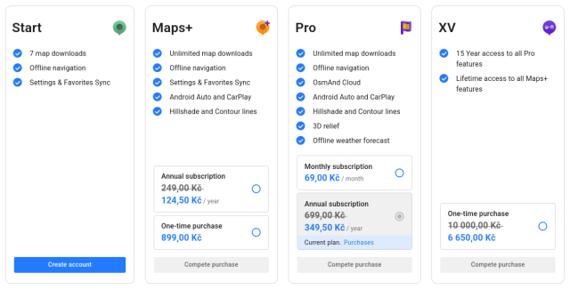
Yes, but... On web I cannot buy "Pro" (by clicking on "Purchase" nothing happens, although I am logged-in - using Firefox on Windows 11). In Android app I see even different prices for "Pro" plan (79,99 CZK / month or 400,00 CZK first year, 799,99 CZK next years). Bummer. #osmand
Just so you know, #OsmAnd is celebrating its 15th anniversary with 50% off its plans, which you can now pay for directly without paying the 'app tax' to Google or Apple.
I highly recommend OsmAnd — it's a Swiss army knife for maps! Open source. Based on #OpenStreetMap.
It took almost 9.5 years to make 20,000 edits with OsmAnd for OpenStreetMap. Thanks to Quick Action it has recently become easier and faster. But since the introduction of Streetcomplete and especially Mapcomplete, I've been mapping a little less with OsmAnd lately. Let's see how long I need for the next 10,000.
When I started mapping the first additions in the OsmaAnd app for Openstreetmap at the end of 2015, I never thought I would make 1 million changes. Entered in OsmAnd and then in Potlach2 (because it was beginner-friendly). Then later iD and other apps. Like Mapcomplete, Streetcomplete or Everydoor. 1 I can only recommend just getting started.
We would also like to #welcome all people joining us today! If you are switching over from #Twitter, #X, #Facebook, #Instagram: welcome into a truly federated social network.
While you've made the switch, consider also moving away from that other big corporation named #Google: a great alternative is #OpenStreetMap . There are many apps (such as @organicmaps or #osmand)
There are also a lot of maps about a specific topic. You can find a collection of them on mapcomplete.org
I finally started to fill data in to #OpenStreetMap. At first I just looked at how several features are already tagged, then slowly started to correct wrong data and then add missing details. I use #StreetComplete app to add details on walk travels, #OsmAnd app to add POIs and of course the iD web editor for larger edits. I am especially impressed by the iD editor. It's so helpfull with clever use of autocomplete and linking to #OSM wiki... The best reward is 3D view becoming more realistic...
Habe gestern einmal ein paar Anregung hinsichtlich der Verbesserung der Zugänglichkeit einiger Elemente in der App #OsmAnd ans Entwicklerteam gemailt, bin mal gespannt. @radiorobbe hat die App unter schulle4u.github.io/awesome-an… aufgenommen. Ich könnte ja mal einen Text zu besagter App und #OpenStreetMap generell verfassen, der dann auf droidblind.de veröffentlicht werden könnte ...
I participated in the #OsmAnd anniversary quiz and now I've won 3 months of OsmAnd pro... Except that:
- I don't need it, as I use the full version from #FDroid - despite that, I somehow still pay a monthly fee to them. (I'm actually not sure who pays that bill though 🤷 )
In other words, send me a PM if you want three months of OsmAnd Pro.
locus je velmi fajn, placena verze za tech par korun stoji
prestal jsem ho pouzivat s prechodem na grapheneos (nevedel jsem jak tam dostat placenou appku) a presel na #OsmAnd ktery muzu taktez doporucit (ale podporu pro geocaching asi nema)
Já Google mapy vůbec nemám. V poslední době v GrapheneOs padala Waze aplikace. Tak jsem nainstaloval z F-droidu #osmand a zatím bez problémů a to musím navigaci využívat několikrát denně.