#OSM #OpenStreetMap #FOSS #SIG #OpenData
Search
Items tagged with: OpenStreetmap
#OSM #OpenStreetMap #FOSS #SIG #OpenData
@april Under 'menu' -> 'download' there are various download options to further process the data; you can embed mapcomplete in an iFrame or create another mapcomplete theme which shows this layer together with other layers.
As usual, all the data is from/goes to #OpenStreetMap, so you are free to reuse the data.
Summer 24 somewhere in Sweden.
After a delicious dinner, we went for a digestive walk with the midnightsun and making some survey. Of course I used the Osmand app with Quick Action function, Streetcomplete and took pictures with Mapcomplete.
#mapping #sweden #osm #OpenStreetMap #osmandapp #streetcomplete #MapComplete
Hi dear #OpenStreetMap -community! I made a #tagging #proposal to tag grab rails (aka grab bars, handrails, support brackets) in #wheelchair #accessible toilets and I'm searching feedback.
I'd appreciate your feedback: wiki.openstreetmap.org/wiki/Pr…
@alan
This screenshot it's in other browser in Android. Instead at Firefox in laptop. So does not seem a cache problem.
Did noticed that it shows Sal Y Canela restaurant with their correct name I've fixed some minutes ago. It was Canela y Sal and I've edited at #openstreetmap website.
So maybe it's only a problem with removed places.
Hi, @MapComplete !
I'm checking the Restaurants and fast food in my area and noted that it's very outdated vs #OpenStreetMap data.
mapcomplete.org/food.html?z=17…
openstreetmap.org/#map=19/40.7…
There shows two restaurants that I removed some months ago and lacks another added about one month ago.
Could be something at my side or map items are updated from time to time?
When I started mapping the first additions in the OsmaAnd app for Openstreetmap at the end of 2015, I never thought I would make 1 million changes. Entered in OsmAnd and then in Potlach2 (because it was beginner-friendly). Then later iD and other apps. Like Mapcomplete, Streetcomplete or Everydoor. 1
I can only recommend just getting started.
#osm #OpenStreetMap #osmand #MapComplete #streetcomplete #EveryDoor #Karten #Landkarte #map #opensource
Máte pár minut volného času, který byste chtěli věnovat na věc sloužící všem? Upravujte #OpenStreetMap ve svém okolí, je to snadnější než tušíte.
Velké firmy jako #SeznamCZ vzali kdysi z OSM vše dostupné (#mapy_cz) a do OSM přestali přispívat.
Je spousta příležitostí, co v OSM aktualizovat: přidat nový obchod, upravit otevírací dobu, přidat odkaz na homepage úřadu, atd. To vše jsou velmi jednoduché kroky v pohodlném online editoru.
#mapy #opensource
Průvodce: wiki.openstreetmap.org/wiki/Cs…
I made a crowdsourced map for climbing stuff once. If there is a shoe shop, you can mark if they do repair climbing shoes as well: mapcomplete.org/climbing?z=13.…
Feel free to add your favourite repair shops too; it is all based (and saved into) #OpenStreetMap

Climbing gyms, clubs and spots
On this map you will find various climbing opportunities such as climbing gyms, bouldering halls and rocks in naturemapcomplete.org
La próxima vez que tengas que hacer un mapa para compartir, no pierdas el tiempo con google maps! usa #umap!
Toma como base las capas de #openstreetmap y te permite añadir diferentes capas geográficas.
Comparte pa'la gente que como yo, no sabían que esto existía.
uMap
uMap te permite crear mapas con capas de OpenStreetMap en un minuto e integrarlos en tu sitio.umap.openstreetmap.fr
#Panoramax - das neue #StreetView!
Vor einigen Jahren wurde #Mapillary an #Meta verkauft. Und auch #Google StreetView möchte vielleicht nicht jeder nutzen.
Mit Panoramax gibt es nun eine #FOSS Alternative. Sie soll dezentral organisiert werden. Dies ist meines Wissens die erste Instanz:
panoramax.openstreetmap.fr
Kleiner Tipp:
Falls man das AdOn #ClearURLs verwendet, kommt man eventuell über die Animation wegen Blockierung von ETags nicht hinaus. Deshalb nutze ich Panoramax als #Firefox-PWA am Desktop.
Panoramax OSM-FR - photo-cartographier les territoires
L'instance Panoramax d'OpenStreetMap France, permet la publication de photos de terrain pour cartographie les territoires.panoramax.openstreetmap.fr
Happy I Love Free Software Day! 💕
Unfortunately, this year I could not join nor organize any in-person celebration, BUT of course I want to share my gratitude to the many, countless #FreeSoftware services I don’t merely use, but actually depend on.
Last year, I decided to focus only on #YunoHost, because it would have been crazy to list all the projects I use and I love.
This time, even if I will most certainly forget someone, I am challenging myself to mention all the #LibreSoftware my life is powered by.
Without further ado, THANK YOU to:
- @yunohost, for powering Nebuchadnezzar
- @fedora, for running my beloved #Framework laptop
- @frameworkcomputer, for designing and building repairable, #Linux-friendly and truly open hardware
- @gnome and @GTK, for being just gorgeous
- @calyxos (thus @LineageOS), for powering my #Fairphone5
- #Obtainium, for making me directly download apps on my phone, and @fdroidorg for distributing them
- #AuroraStore, for proxying the download of apps I am doomed to get from Google Play
- @element, for developing #Synapse, even though the new proprietary Synapse Pro is VERY PROBLEMATIC AND DISAPPOINTING
- #Fractal, for being the most beautiful and awesome #Matrix client ever
- @signalapp, for keeping me connected with the people I love
- @Mastodon, for also maintaining a feature-packed experimental fork (#GlitchSoc), that is what Pan runs
- #Tuba and #Moshidon, for being the most beautiful and awesome #Mastodon clients ever
- #Firefox, for still remaining the best possible #browser choice, despite #Mozilla’s governance messiness
- @openstreetmap, for allowing us to find the right path, both literally and metaphorically!
- @organicmaps, for being the simplest, cleanest, yet feature-rich #OSM client and navigation app
- @protonvpn, for making me browse safely from/to anywhere in the planet and @protonprivacy #ProtonMail, for hosting my email, despite the latest alarming political statements…
- @libreoffice, for allowing me to draft documents with ease, the last of which was my #CV
- #LanguageTool, for preventing me from making embarassing spelling mistakes
- @photoprism, for safely storing and indexing all my photographic memories, on Aby, and for providing stellar and friendly support too!
- #Actual, for moderating the very likely risk of ending up completely broke, since it forces me to manage my finances consciously and coherently
- @readeck, for storing and sorting ALL my varied and overwhelming inputs
- @nextcloud, for storing and synchronizing my data, for its #calendar, its #tasks, and all its awesome apps
- #Rustdesk, for preventing my friends and family members from going crazy, by allowing me to remotely connect to their devices and directly address the issues they have
- #Listmonk, for sending out my newsletter
- @eleventy, for powering all the websites I maintain, above all the virtual representation of my mind, and for being the only reason why I resist and try to continue learning #JavaScript
- @forgejo, for giving us a chance to truly control and collectively develop the sources of our software, but most importantly @Codeberg, for RESISTING, RESISTING, RESISTING, despite the hatred and attacks nazi assholes throw at them
- @musicbrainz for keeping music knowledge open and free, and @ListenBrainz for scrobbling the crazy music I listen to
- The @fsfe, for promoting this celebration and fighting the good fight!
Lastly, but most importantly, the biggest thank you goes to all the free software libraries and dependencies the above mentioned #software are made of/built with, including #C, #JavaScript, #Python, #Rust, and all community-maintained programming languages.
I am super sorry if I forgot someone!
#OpenSource #ILoveFS #SoftwareFreedom #Fairphone #Android #LineageOS #FSFE #OpenStreetMap #PhotoPrism #LibreOffice #Readeck #Eleventy #11ty #GNOME #Signal #forgejo #Codeberg #MusicBrainz #ListenBrainz #MetaBrainz

Nebuchadnezzar
Information and insights concerning the configuration and maintenance of Tommi’s server.Tommi (Tommi’s mind)
📢 January 2025 Newsletter is here! We’re kicking off the year with exciting updates:
⚙️ Rust support progress for Native
🔤 Web font improvements in GL JS
💡 Read more: 🔗 maplibre.org/news/2025-02-03-m…
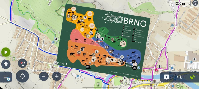
There is one feature of #LocusMap that I really like: you can take a picture of a map, calibrate it with the standard map and then have it as an overlay.
Very handy when you take the kids to the zoo or amusement park. 👌
#maps #map #OpenStreetMap
#OpenStreetMap is also 100% crowdsourced and 100% reusable by anyone.
mapcomplete.org allows people to contribute back data by filling out the questions asked when an item is selected. So, feel free to help out!
MapComplete - editable, thematic maps with OpenStreetMap
MapComplete is a platform to visualize OpenStreetMap on a specific topic and to easily contribute data back to it.mapcomplete.org
We would also like to #welcome all people joining us today! If you are switching over from #Twitter, #X, #Facebook, #Instagram: welcome into a truly federated social network.
While you've made the switch, consider also moving away from that other big corporation named #Google: a great alternative is #OpenStreetMap . There are many apps (such as @organicmaps or #osmand)
There are also a lot of maps about a specific topic. You can find a collection of them on mapcomplete.org
MapComplete - editable, thematic maps with OpenStreetMap
MapComplete is a platform to visualize OpenStreetMap on a specific topic and to easily contribute data back to it.mapcomplete.org
I've been finding @everydoor to be a brilliant app for editing #OpenStreetMap while out and about (or in a warm café with view of shops across the road).
This is my first video about it youtu.be/zWrDM1fZEnU?si=2W-XhI…

Using Every Door to improve OpenStreetMap
I've been speeding up my #OpenStreetMap contributions with this app, and hopefully keeping more things up to date.https://every-door.app/This is a little int...YouTube
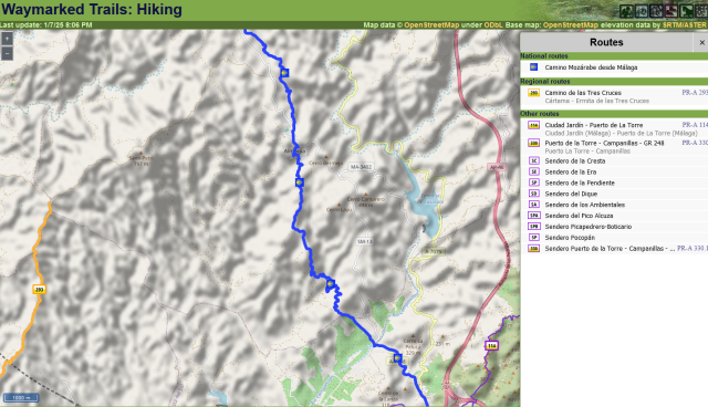
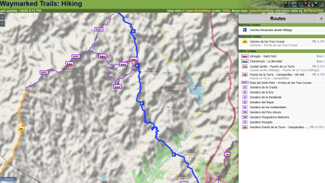
Following a couple of days walking around Almogía over the Christmas break, I've added 3 local signposted hiking trails to OSM.
I'm especially pleased that OSM-based outdoor maps will now show connections between the Camino Mozárabe to the east and the PR-A 293 to the west, via the summit of Santi Petri. Both were already mapped, but until now it was difficult to be sure from online information if there was a waymarked route between them.
Before and after screenshots:
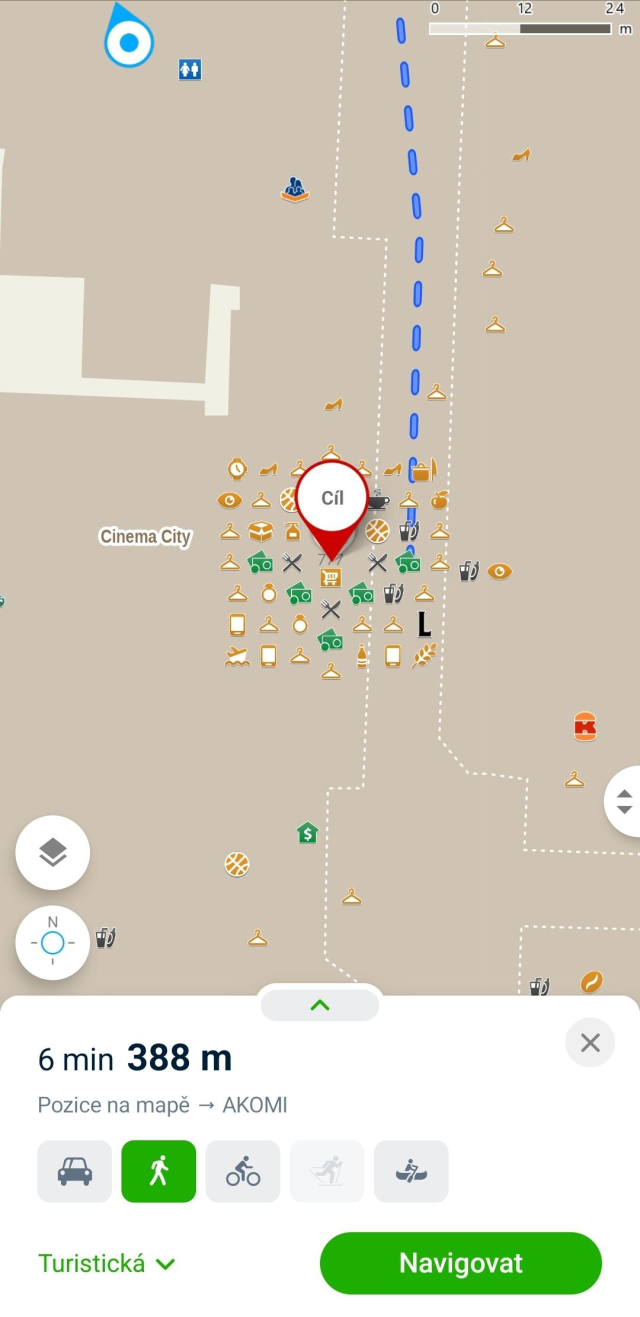
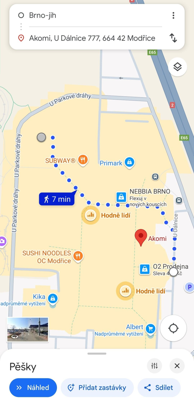
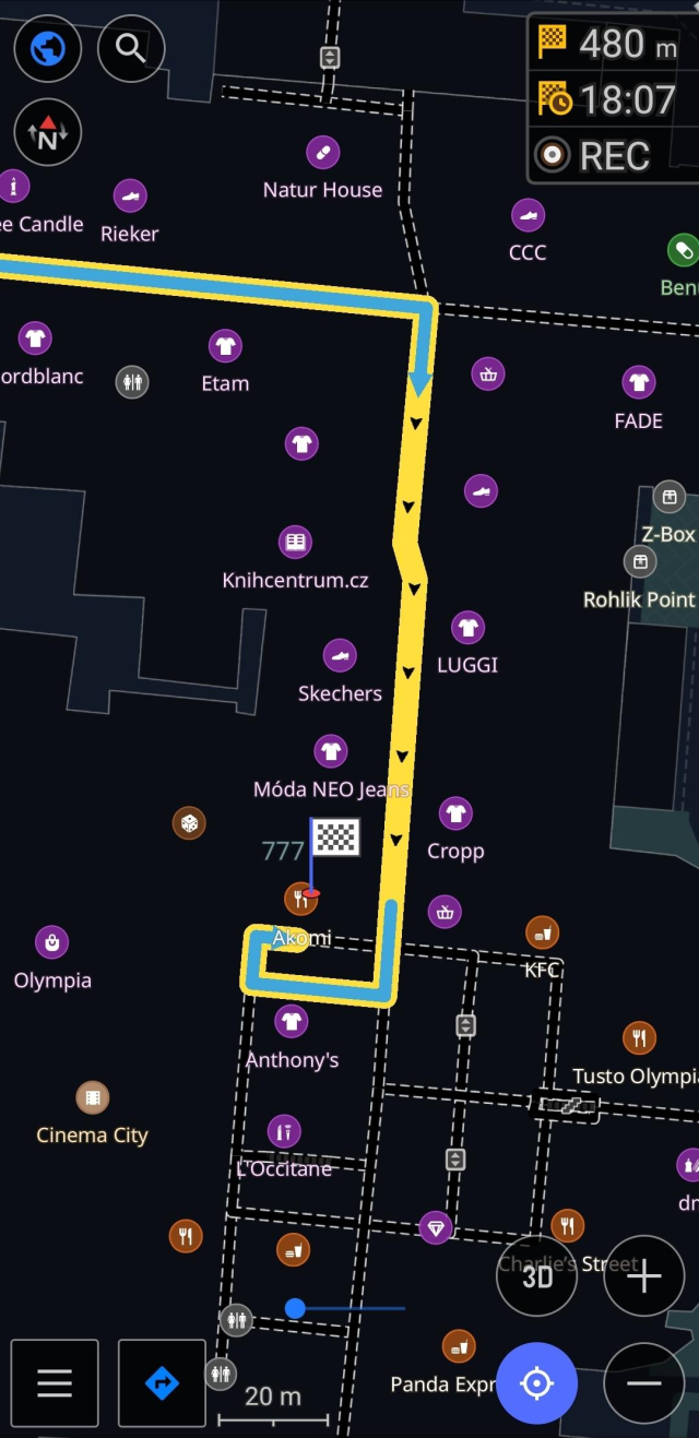
I hate big shopping malls. That's why I always need to find the best way to the business and back. #Mapycz and #GoogleMaps are useless for that. POIs are missing, wrongly placed or grouped in the middle of the mall.
But some shopping malls in #Brno are so well mapped in #OpenStreetMap that it can navigate me right to the business. And that even includes changing floors and using escalators. 👍
#OpenStreetMap is back on its feet.
Making edits with MapComplete is thus possible again as well.
We have a new version out too (but it got a bit overshadowed).
Some highlights:
- There is an insect-hotel theme (mapcomplete.org/insects.html) (thanks @RLin )
- The cyclofix, climbing, blind maps got some improvements (thanks to @midgard amongst others)
- Etymology-map will now also show parks without etymology, in order to be able to link them
- and a lot of bug fixes
Vielen Dank für den Tipp!
Ich finde es schön, dass man bei #OpenStreetMap auch selbst beitragen und auch viele Details kartographieren kann.
@openstreetmap@en.osm.town
#Mapycz are now launching their premium version. I'm not sure if it is in response to that. But #LocusMap, a lovely #OpenStreetMap based app focused on outdoor activities built by a small company from #Prague, now has a 6 month trial of their premium plans. Check it out! 👇

Locus Map - mobile outdoor navigation app
Multi-functional mobile outdoor navigation app for hiking, cycling, geocaching, sailing, flying and other sports activities and travelingLocus Map - mobile outdoor navigation app
OpenStreetMap migrates to Debian 12: You may have seen this toot
announcing OpenStreetMap's migration to Debian on their infrastructure.
🚀 After 18 years on Ubuntu, we've upgraded the
@openstreetmap servers to Debian 12
(Bookworm). 🌍 openstreetmap.org is now faster
using Ruby 3.1. Onward to new mapping adventures! Thank you to the team for
the smooth transition.
#OpenStreetMap
#Debian 🤓
We spoke with Grant Slater, the Senior Site Reliability Engineer for the… bits.debian.org/2024/11/openst…

OpenStreetMap migrates to Debian 12
You may have seen this toot announcing OpenStreetMap's migration to Debian on their infrastructure. 🚀 After 18 years on Ubuntu, we've upgraded the @openstreetmap servers to Debian 12 (Bookworm). 🌍 openstreetmap.org is now faster using Ruby...Debian Project
#Seznam, the company behind Mapy.cz, has become a silver partner of the #OpenStreetMap Foundation.
It was about time. They've been benefiting from #OSM for years.
Now I have one last thing on my wishlist: Drop the proprietary maps for #Czechia and use OSM everywhere.
blog.seznam.cz/2024/11/mapy-cz…

Mapy.cz nově finančně podporují projekt OpenStreetMap, a pomáhají tak přispívat na jeho provoz a rozvoj
Česká mapová aplikace díky firemnímu členství nyní aktivně podporuje rozvoj OpenStreetMap. Projekt je jedním z klíčových zdrojů otevřených dat, o něž se Mapy.cz opírají.Veronika Geltner (Seznam.cz)
Angaben zur #Rollstuhltauglichkeit eines Ortes sind zwar in der @openstreetmap@en.osm.town eingetragen, werden aber auf der #wheelmap nicht angezeigt?
Dann könnte es sein, dass die Beschreibung nicht dem Basis-Attribut wheelchair_description sondern dem mit der Erweiterung der Sprache zugeordnet wurde, z.B. wheelchair_description:de
Wie mir der Support mitteilte, arbeitet man aber daran, auch die Sprachdefiition zu berücksichtigen.
wheelmap.or
#Accessibility #Barrierefreiheit #Inklusion #OSM #OpenStreetMap
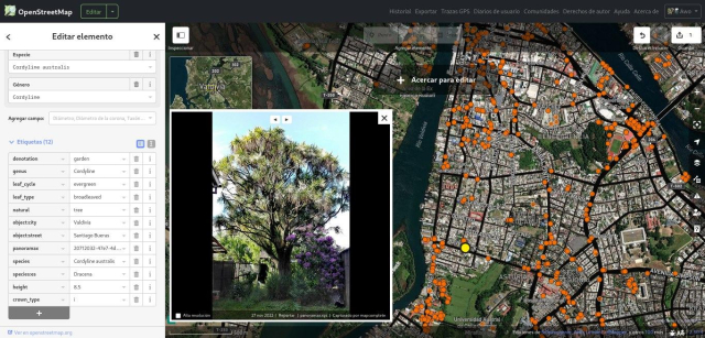
A great screenshot by @pauldassori , showing many pieces of software working together.
It shows the iD #OpenStreetMap - editor opened in #Valdivia . A lot of orange dots are visible: these are locations for which panoramax.xyz knows an image for. This #panoramax-instance federates with panoramax.mapcomplete.org, which hosts the images made with mapcomplete.org
As Awo (osm.org/user/Awo) has added many pictures with @MapComplete , a lot of pictures are shown!
MapComplete - editable, thematic maps with OpenStreetMap
MapComplete is a platform to visualize OpenStreetMap on a specific topic and to easily contribute data back to it.mapcomplete.org
Eine Frage an Mitleser aus Österreich community.openstreetmap.org/t/…

Graphenintegrations-Plattform
Eine, etwas längere, Frage aus dem Nachbarland. Die swisstopo arbeitet schon länger am “Verkehrsnetz Schweiz” das zukünftig als Datengrundlage für ihre Dienste (Routing, Geocoding etc) in Konkurrenz zu google, Apple, Here, Tomtom und natürlich auch …OpenStreetMap Community Forum
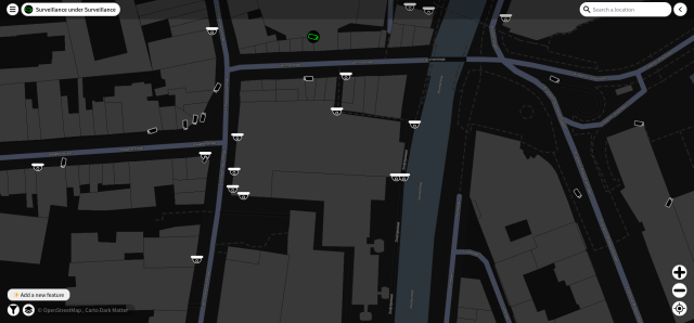
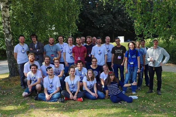
Tomorrow and saturday, we are doing a #surveillance #camera walk in #Ghent: see meetup.com/openstreetmap-belgi… and meetup.com/openstreetmap-belgi…
We will be adding them to #OpenStreetMap using @MapComplete
Bewakingscamera's op de kaart (wandeling)
Hoeveel bewakingscameras zijn er in Gent? Waar staan ze (niet)? Hoe kunnen we dit in kaart brengen? Is dit goed of slecht voor de maatschappij? In deze woMeetup
New OSM tool (to me):
It is an easy way to see where lights are already mapped, and what still needs to be covered. I do believe MapComplete has one as well.
Street Lamps in OSM
This map shows street lamps and their settings in the data of OpenStreetMap. It shows e.g. operators, reference numbers and details about the used lights.sb12.github.io
Murals can also be added and uploaded to #OpenStreetMap with mapcomplete.org/artwork
Those pictures might be posted by @mapcomplete_edits
Looking for vegan places and not a fan of proprietary datasets? #MapComplete has several themes to find (and edit) vegan places, based on #OpenStreetMap data!
The “restaurants and fast food” theme will show most places you might be interested in. If you love fries (like I do), “fries shops” will be helpful for you. And in the “gluten free” and “lactose free” themes, you can filter for vegan places too!
You can also easily edit these places with MapComplete, for example to add details or update incorrect or outdated information. Your changes will be uploaded to OpenStreetMap, which is freely reusable data!
MapComplete - editable, thematic maps with OpenStreetMap
MapComplete is a platform to visualize OpenStreetMap on a specific topic and to easily contribute data back to it.mapcomplete.org
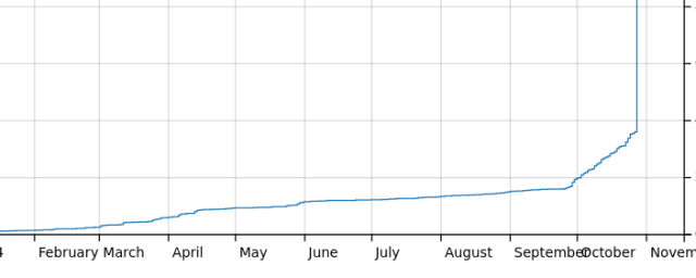
I moved nearly 40K pictures (which were linked from #OpenStreetMap and created with @MapComplete from imgur to @panoramax
You can read more about the proces
openstreetmap.org/user/Pieter%…
Thanks to @thibaultmol for hosting the server
Moving pictures from IMGUR to Panoramax: some thoughts and little facts
As you might know, Im the main developer of MapComplete. For those who dont know, MapComplete is an OSM-viewer and editor, where contributors can easily answer questions, add new points and upload pictures from a POI from a cozy website.OpenStreetMap
nice service by @jaller94: find missing #stolpersteine on #osm in your berlin kiez. simply load the gpx file into your favourite osm app (e.g. osmand) and add missing stolpersteine to #openstreetmap.
gpx-files: osm-check.chrpaul.de/report/st…
sourcecode: gitlab.com/jaller94/osm-check-…
Hey würde jemand Lust verspüren sich beim Betrieb eines deutschen #panoramax Servers einzubringen? Streetview Photos unter CC und für OSM 
community.openstreetmap.org/t/…
#selfhosting #openstreetmap #fossgis #gistribe #datenschutz #photografie

Deutscher Panoramax Server?
Wenn es um das Problem des Hostens der Bilder geht könnte man vielleicht gucken, dass man die Bilder einfach auf Wikimedia Commons speichert und Panoramax nur als Viewer für die auf den Wikimedia Servern liegenden Fotos nutzt.OpenStreetMap Community Forum
We moved about 10K images already, about 2.8% of all 'image'-tags in the #OpenStreetMap-database. All those moved images are made in Flanders.
There are 19K images hosted on Imgur, of which the vast majority (probably 18K) are made with MapComplete and will be moved soon.
If your app supports the image tag, it might be neat to start supporting panoramax too. See the wiki for details. OpenAEDMap just implemented it (see github.com/openstreetmap-polsk…, might not be live ATM)

Add support for panoramax · openstreetmap-polska/openaedmap-backend@c035154
❤️ Backend powering OpenAEDMap.org — an OpenStreetMap's life-saving AED map - Add support for panoramax · openstreetmap-polska/openaedmap-backend@c035154GitHub
Op vrijdag 22 november (13u30) en zaterdag 23 november (11u) organiseer ik een wandeling vanuit de Krook in #Gent waar we met #OpenStreetMap en @MapComplete bewakingscamera's in kaart gaan brengen.
Na een korte uitleg gaat iedereen een eigen kant op, op zoek naar camera's.
Dit past binnen mutationfest.be/program
(Of je kan ook meer info vinden op de meetup-pagina: meetup.com/openstreetmap-belgi…)
#privacy #bewakingscameras #surveillance

Programma | Mutation
Ontdek de rode draad die vier unieke locaties aan Gent Zuid verbindt. Laat je drie dagen verwonderen door een intensief programma.Mutation
AWESOME new @kagihq update:
For ex: I want to look at the #OpenStreetMap wiki page for (power) sockets.
Previously you could do search like this:
socket !osmwiki
this would bring you to wiki.openstreetmap.org/wiki/Sp…
But if I know that the chance of the right page being the first result on #Kagi is high, I can just do:
socket @osmwiki !
then I land on: wiki.openstreetmap.org/wiki/Ke…:*
! is basically the Kagi equivalent of that google "i'm feeling lucky" feature from back in the day


